Kilauea Volcano Erupts; Alert Levels, Hazards, US Geological Survey Monitoring, Lava Maps
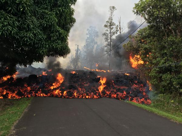
View of a fissure from Luana Street near fissure 2 and 7, Leilani Estates; USGS video

Lava moving along Makamae Street, Leilane Street, Leilani Estates on May 6th, USGS photo
This is a developing story, so please keep checking the USGS Hawaiian Volcano Observatory Kīlauea status website for daily activity updates. In addition to status updates, public-domain current photos, videos, and maps are also available. You can also visit the USGS home page, the USGS Facebook page, and the USGS Twitter feed as updates become available.
Monday, May 14, 2018, 8:36 AM HST (Monday, May 14, 2018, 18:36 UTC)
KILAUEA VOLCANO (VNUM #332010)
19°25'16" N 155°17'13" W, Summit Elevation 4091 ft (1247 m)
Current Volcano Alert Level: WARNING
Current Aviation Color Code: ORANGE
Summary:
LOWER EAST RIFT ZONE
Eruption of lava continues from multiple points along the northeast end of the active fissure system. Residents in lower Puna should remain informed and heed Hawaii County Civil Defense closures, warnings, and messages (http://www.hawaiicounty.gov/active-alerts)
This morning, activity is dominated by lava fountaining, explosion of spatter more than 100 feet into the air, and an advancing lava flow from fissure 17 at the northeast end of the fissure system. As of 630 am the fissure 17 flow had traveled just under a mile roughly east-southeast parallel to the rift zone. It is turning slightly south and at this time is about one half mile south of Highway 132.
Fissure 18 that became active late yesterday is weakly active.
A fissure 19 has been spotted very near fissure 15 as of about 8 am just northeast of Pohoiki Road and north of Hinalo Street at the east end of Lanipuna Gardens. It is producing a sluggish lava flow.
Volcanic gas emissions remain elevated throughout the area downwind of the vents. Yesterday with the onset of activity at fissure 17, powerful steam jets have occurred intermittently near the west end of the fissure. These jets may be responsible for some of the loud sounds reported by residents and emergency workers.
For the most recent map showing the locations of activity, please see https://volcanoes.usgs.gov/volcanoes/kilauea/multimedia_maps.html
HVO field crews are on site tracking the lava flow as conditions allow and reporting information to Hawaii County Civil Defense.
This eruption is still evolving and additional outbreaks of lava are possible. Ground deformation continues and seismicity remains elevated in the area.
The location of future outbreaks could include areas both uprift (southwest) and downrift (northeast) of the existing fissures, or, existing fissures can be reactivated. Communities downslope of these fissures could be at risk from lava inundation. Activity can change rapidly.
Conditions around the erupting fissures can change very quickly. Residents in lower Puna should remain informed and heed Hawaii County Civil Defense closures, warnings, and messages (http://www.hawaiicounty.gov/active-alerts).
KILAUEA SUMMIT
Deflationary tilt at the summit of the volcano continues and seismicity remains elevated. Last night several strong earthquakes shook HVO and the surrounding area.
This morning, a steady, vigorous plume of steam and occasionally minor amounts of ash is rising from the Overlook vent and drifting downwind to the southwest. As has been observed over the past several days, occasional rockfalls into the deep vent are expected produce intermittent pulses of slightly more vigorous ash emissions. Depending on wind conditions, dustings of ash may occur in the Kilauea summit area and downwind. More energetic ash emissions are possible if explosive activity commences.
Current webcam views are here: https://volcanoes.usgs.gov/volcanoes/kilauea/multimedia_webcams.html
REMARKS
USGS/HVO continues to monitor the situation at the summit and the lower East Rift Zone 24/7 in coordination with Hawaii County Civil Defense and other emergency authorities. HVO geologists are onsite in the area this morning conducting overflights, examining the fissure vent activity for significant changes, and searching for any signs of new or resumed activity.
Please see this link for newly organized information about ash hazards, gas hazards, and the Lower East Rift Zone eruption. https://vog.ivhhn.org/
Hawaii County Civil Defense messages regarding conditions, warning, and evacuations may be found at http://www.hawaiicounty.gov/active-alerts/.
MORE INFORMATION
Activity Summary also available by phone: (808) 967-8862
Subscribe to these messages: https://volcanoes.usgs.gov/vns2/
Webcam images: https://volcanoes.usgs.gov/volcanoes/kilauea/multimedia_webcams.html
Photos/Video: https://volcanoes.usgs.gov/volcanoes/kilauea/multimedia_chronology.html
Lava Flow Maps: https://volcanoes.usgs.gov/volcanoes/kilauea/multimedia_maps.html
Definitions of terms used in update: https://volcanoes.usgs.gov/volcanoes/kilauea/extra/definitions.pdf
Overview of Kīlauea summit (Halemaʻumaʻu) and East Rift Zone (Puʻu ʻŌʻō ) eruptions:
https://volcanoes.usgs.gov/volcanoes/kilauea/extra/background.pdf
Summary of volcanic hazards from Kīlauea eruptions:
https://volcanoes.usgs.gov/volcanoes/kilauea/extra/hazards.pdf
Recent Earthquakes in Hawai'i (map and list):
https://volcanoes.usgs.gov/hvo/earthquakes/
Explanation of Volcano Alert Levels and Aviation Color Codes:
https://volcanoes.usgs.gov/activity/alertsystem/index.php
https://pubs.usgs.gov/fs/2006/3139/
CONTACT INFORMATION:
askHVO@usgs.gov
The Hawaiian Volcano Observatory is one of five volcano observatories within the U.S. Geological Survey and is responsible for monitoring volcanoes and earthquakes in Hawai`i.
More Articles


