In 2010, while conducting the first systematic multibeam mapping surveys of part of the shelf edge and slope in the Canadian Beaufort Sea, researchers found a band of unusually rough seafloor terrain along a 95-kilometer (59-mile) stretch of the shelf roughly 180 kilometers (110 miles) offshore, along what was once the seaward limit of relict Pleistocene permafrost. Repeated surveys allowed researchers to begin to understand the processes creating the distinctively rugged seafloor terrain in the Canadian Beaufort Sea.
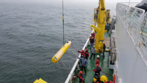
The three subsequent multibeam surveys — with AUVs in 2013 and 2017 and by ship in 2019 — provided high-resolution maps of a smaller area of 4.8 square kilometers (1.9 square miles) near the edge of submerged permafrost 120 to 150 meters (394 to 492 feet) deep to help researchers understand the processes responsible for the unique seafloor features first observed in 2010. The differences measured in these surveys over a nine-year period provided three snapshots of rapid and dynamic changes in seafloor morphology.
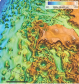
Researchers documented the formation of new, irregularly shaped, steep-sided depressions. The largest was an oval-shaped depression 28 meters (92 feet) deep, 225 meters (738 feet) long, and 95 meters (312 feet) wide. The research team attributes these changes to intermittent seafloor collapse due to the gradual warming of the permafrost sediment frozen beneath the Arctic Shelf since the end of the last ice age.
The degradation of terrestrial Arctic permafrost is attributed, in part, to increases in mean annual temperature from human-driven climate change. The changes the research team documented derive from much older, slower climatic shifts related to our emergence from the last ice age, and similar changes appear to have been happening along the seaward edge of the former permafrost for thousands of years.
“We don’t have a lot of long-term data for the seafloor temperature in the Canadian Beaufort Sea, but the available data do not show a warming trend, which ruled out anthropogenic climate change driving the dramatic changes in the seafloor terrain. Instead, heat carried in slowly moving groundwater systems is driving these changes,” explained Paull.

MBARI’s mapping AUVs detailed the unusually rough seafloor terrain along the edge of the continental shelf in the Canadian Arctic. Sinkholes have developed where permafrost ice at depth has thawed, forming voids into which the seafloor collapsed. The circular mounds formed where the brackish water produced from the relict permafrost decay has migrated upwards and frozen, blistering the seafloor with ice-cored mounds called pingos. Image: Eve Lundsten © 2022 MBARI
Brackish groundwater generated from the thawed permafrost percolates upwards along the bottom edge of the remaining relict permafrost bodies, accelerating the thawing of the permafrost in the sediments above. Water-filled cavities replace the excess ice that was once within the relict permafrost. Previously permafrost-filled subsurface voids periodically collapsed to produce the large and rapidly formed sinkholes observed on the seafloor.
The research team also documented other distinct seafloor features created by water from thawing permafrost.
In areas where groundwater discharge is more limited, the bottom ocean waters keep the near-seafloor sediment temperature low enough for the ascending brackish waters to refreeze as they approach the slightly colder seafloor. When ice in near-seafloor sediments freezes, it expands, creating pingos—circular hills with a core of ice. The maps of the seafloor revealed an abundance of pingos adjacent to the main discharge area. While pingos were previously viewed primarily as a terrestrial landform, this study has confirmed these features are in fact submarine pingos. The density of these pingos is the highest known anywhere.
“The ongoing melting of relict permafrost under the Arctic Shelf, expulsion of brackish waters, and the formation of new ground ice within the near seafloor sediments work in concert to create the unique and rapidly changing morphology observed on the Arctic seabed,” said Paull. “These rapid changes to the seafloor demand our attention. We need to understand how the decay of relict submarine permafrost will impact the vast areas underlying the Arctic continental shelves. This groundbreaking research has revealed how the thawing of submarine permafrost can be detected, and then monitored once baselines are established.”
The team expects that similar processes may also be occurring in other submarine permafrost systems. How widespread similar changes are on the Arctic shelves remains unknown, as this is one of the first areas in the Arctic studied with multiple multibeam bathymetric surveys. However, permafrost thawing may be an important process in sculpturing the seafloor throughout the Arctic.

In 2022, MBARI will join collaborators from the Geological Survey of Canada, the Department of Fisheries and Oceans Canada, the Korean Polar Research Institute, and the United States Naval Research Laboratory for an expedition aboard the Korean icebreaker Araon (pictured) for further research on the thawing submarine permafrost in the Canadian Beaufort Sea. Image: Roberto Gwiazda © 2017 MBARI
The research team will return to the Arctic this summer aboard the R/V Araon, a Korean icebreaker. This trip with MBARI’s long-time Canadian and Korean collaborators—along with the addition of the United States Naval Research Laboratory — will help refine our understanding of the decay of submarine permafrost.
Two of MBARI’s AUVs will map the seafloor in remarkable detail and MBARI’s MiniROV — a portable remotely operated vehicle — will enable further exploration and sampling to complement the mapping surveys.
The Canadian Beaufort Sea, a remote area of the Arctic, has only recently become accessible as climate change drives the retreat of sea ice. Learning about the fragile Arctic environment before it becomes further altered by the expanding human presence is especially important and urgent. This ongoing research in the Arctic and the upcoming expedition exemplify MBARI’s mission to advance ocean science and technology to understand a changing ocean.
Original journal article:
Paull, C.K., S.R. Dallimore, Y.K. Jin, D.W. Caress, E. Lundsten, R. Gwiazda, K. Anderson, J.H. Clarke, S. Youngblut, and H. Melling (2022). Rapid seafloor changes associated with the degradation of Arctic submarine permafrost. Proceedings of the National Academy of Sciences, 119: e2119105119. doi.org/10.1073/pnas.2119105119
Pages: 1 · 2


